
Weather 101 / History
The Great Atlantic Hurricane of 1944: The Wartime Storm That Wrecked Atlantic City's Boardwalk
On the evening of September 14, 1944, with World War II still underway, a large and powerful hurricane raced north just off the New Jersey coast. It never officially made landfall here. But it passed close enough to wreck Atlantic City's Boardwalk, flood Long Beach Island and raise the biggest storm surge at Atlantic City of any hurricane that passed offshore between 1912 and 1969. It is also remembered for the ships it sank and for arriving in the first year of the aircraft reconnaissance era.
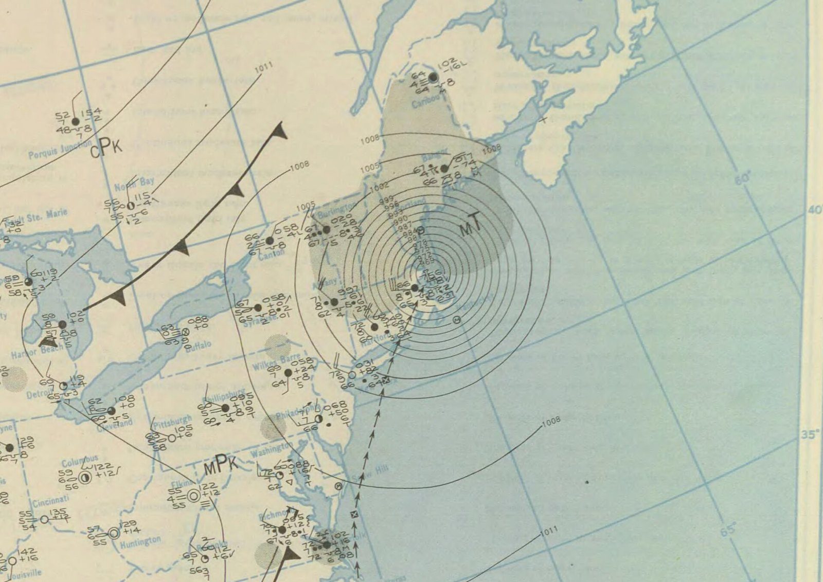
Where it came from
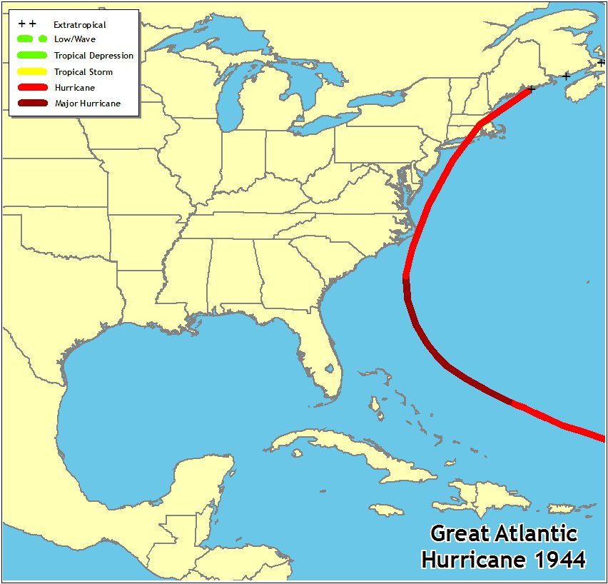
According to the National Hurricane Center (NHC), the hurricane was first detected northeast of the Leeward Islands on September 9. It moved west-northwest through the 12th, then turned north on a track that brought the center near Cape Hatteras, North Carolina, on the 14th. From there it sped up toward the north-northeast, crossed eastern New England and reached Canada by September 15, where it lost its tropical characteristics.
At its peak on September 13, well out over the Atlantic east of Florida, NHC's official storm database (called HURDAT2) lists top winds near 160 mph and a central pressure of 918 millibars. On today's scale, that is a Category 5 hurricane.
How close it came to New Jersey
By the time it reached us, the hurricane was moving fast. NHC's track positions show it covering about 390 miles between the morning and evening of September 14, a forward speed of more than 30 mph.
- Off the Jersey coast: NHC's position for the evening of the 14th puts the center east of Monmouth County, with winds near 105 mph and a pressure of 954 millibars.
- Distance from the beaches: Weather Bureau and NWS technical reports from 1970 and 1976 put the center about 30 miles east of Atlantic City. Today's NHC track places it a little farther out; by our estimate from that track, roughly 40 to 60 miles off the coast from Cape May to Sandy Hook.
- Landfall: About two hours later, the center came ashore on eastern Long Island. NHC's history summary calls it a Category 3 at its landfalls in North Carolina, on Long Island and in Rhode Island. NHC's current best-track data list it at about 105 mph when it reached Long Island, which is Category 2.
It also arrived at a bad time. An NWS technical report notes the storm passed the New Jersey coast near the time of high astronomical tide, which made the flooding much worse.
At the Jersey Shore
National Weather Service studies of the storm's tides describe the damage along our coast:
- Atlantic City: the storm destroyed the Steel Pier and most of the Boardwalk. Atlantic City's fastest-mile wind reached 91 mph, one of several places where the storm equaled or broke the old wind records.
- Long Beach Island and Absecon Island: these two barrier islands took the greatest damage in New Jersey, from high storm tides and extensive flooding.
- Cape May: gusts reached 92 mph, and the tide at the Naval Air Station in Cape May reached 8.0 feet.
- Raritan Bay: the high water reached the bay too, with a 7.4-foot tide at Perth Amboy.
At Atlantic City, an NWS study of hurricanes from 1912 to 1969 ranked the 1944 storm's 5.1-foot surge as the largest from any hurricane passing offshore. Today, NWS Mount Holly's tide list for the Atlantic City gauge shows the September 14, 1944 tide at 8.8 feet above mean lower low water. That ties Sandy in 2012 and trails only the December 1992 nor'easter at 9.0 feet. (Older reports used different reference levels, so their tide numbers aren't directly comparable with this one.)
We could not find an official count of deaths in New Jersey, or official damage reports for Asbury Park and the rest of Monmouth County, so we have left those out.
The ships lost at sea
The deadliest part of this hurricane was offshore, where wartime shipping was heavy. NHC says five vessels sank because of the storm: a U.S. Navy destroyer, a Navy minesweeper, two U.S. Coast Guard cutters and a lightship (a floating lighthouse). Those sinkings caused 344 deaths. On land, NHC's history page counts 46 deaths in the United States, while a later NHC technical report lists 64. Both put the total, including the losses at sea, at about 390 lives. Damage in the United States came to about $100 million in 1944 dollars.
Why it's not called a New Jersey hurricane
NHC's technical reports count a "direct hit" when a coastal county falls inside the zone of a hurricane's strongest winds where it comes ashore, or where it makes its closest approach. For the September 1944 storm, NHC's list of affected states is North Carolina, Virginia, New York, Connecticut, Rhode Island and Massachusetts. New Jersey isn't on it, and NHC credits our state with only two direct hurricane hits from 1851 to 2010, both Category 1. The 1944 storm shows how little that count says about the danger to a coast that faces the open Atlantic.
The first hurricane-hunter season
Before airplanes, forecasters had to piece together a hurricane's location from ship reports and coastal stations, and a storm far out at sea could be missed entirely. NHC's technical report on U.S. hurricanes marks 1944 as the start of aircraft reconnaissance, and this hurricane came in that very first season. Today, hurricane hunter planes, satellites, radar and computer models follow storms like this one from the day they form, so a hurricane on this track would come with days of warning.
What it means today
A storm does not have to make landfall in New Jersey to cause serious trouble here. A large hurricane passing 30 to 60 miles offshore can still bring destructive wind, battering waves and major tidal flooding, especially if it arrives near high tide and is moving fast.
- Watch the cone, not just the center line: the forecast track can shift, and a storm's effects reach far beyond its center.
- Know the alerts: learn the difference between a watch and a warning before a storm arrives, and follow evacuation orders for your town.
- Check the tide timing: a surge that lands at high tide does far more damage than the same surge at low tide.
For a modern example of how much damage a storm can do here, see our look at Hurricane Sandy by the numbers.
- National Hurricane Center: Hurricanes in History (Great Atlantic Hurricane 1944)
- National Hurricane Center: Atlantic hurricane database HURDAT2, 1851 to 2025
- NOAA Technical Memorandum NWS NHC-6: The Deadliest, Costliest, and Most Intense United States Tropical Cyclones from 1851 to 2010
- NOAA Technical Memorandum NWS HYDRO-32: Storm Tide Frequency Analysis for the Open Coast of Virginia, Maryland, and Delaware (1976)
- ESSA Technical Memorandum WBTM HYDRO 11: Joint Probability Method of Tide Frequency Analysis Applied to Atlantic City and Long Beach Island, N.J.
- NWS Mount Holly: Atlantic County tidal flooding reference, Atlantic City tide gauge
For dangerous weather, always follow official National Weather Service warnings and your local emergency officials.