ALERTSDaily forecast maps are back. For current watches and warnings, always check weather.gov.
New Jersey Weather Center logo New JerseyWeather Center

Archive › Tropics

Archived · Tropics · Fri, Oct 9, 2026, 11 AM EDT

Hurricane Isaias: landfall tonight on the Gulf Coast, rain for New Jersey Sunday (Advisory 12)

Archived post. This was posted Fri, Oct 9, 2026, 11 AM EDT and has been replaced by newer information. It's kept for reference, not current conditions. For the latest, see the homepage.
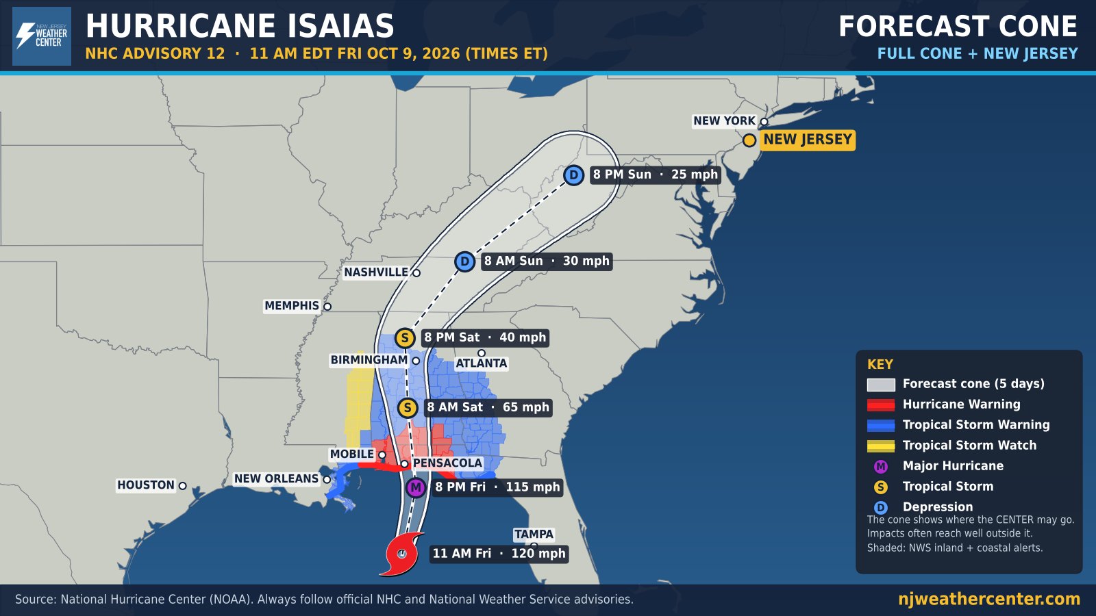
Forecast cone map for Hurricane Isaias, National Hurricane Center Advisory 12, 11 AM EDT Friday, October 9. Isaias is a major hurricane in the Gulf of Mexico with 120 mph winds, forecast to reach the western Florida Panhandle Friday evening, weaken over Alabama Saturday, and move northeast toward West Virginia by Sunday evening. Hurricane Warnings cover the Alabama and Florida Panhandle coast and reach inland; Tropical Storm Warnings cover much of Alabama and western Georgia and the Mississippi and Louisiana coast. New Jersey is marked in gold, outside the cone.

As of 11 AM Friday, Hurricane Isaias is a Category 3 hurricane with 120 mph winds, about 195 miles south of Pensacola, moving north-northeast at 16 mph. The National Hurricane Center expects landfall this evening in the western Florida Panhandle, at or near major hurricane strength.

The cone map shows the whole forecast cone and New Jersey on one map. The red and blue areas are the Hurricane and Tropical Storm Warnings, including the inland ones from local National Weather Service offices. Hurricane-force winds could reach as far as 100 miles inland into southern Alabama.

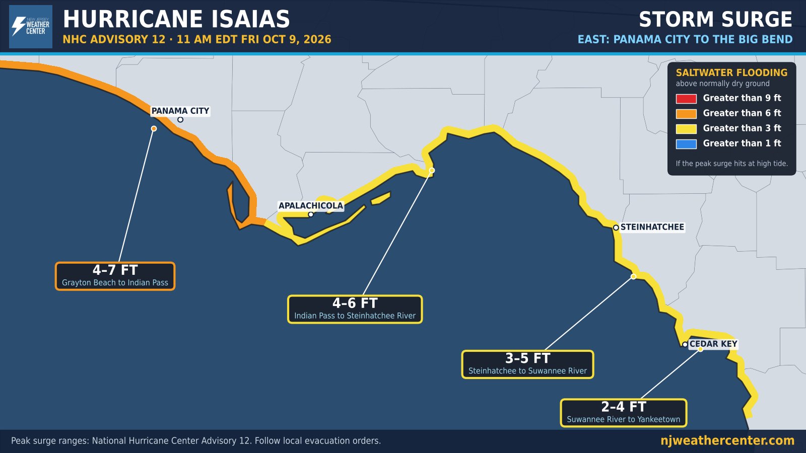
Storm surge: the worst is expected from the Alabama/Florida border to Grayton Beach, where water could reach 6 to 9 feet above normally dry ground if the peak surge comes at high tide. Most of the rest of the Florida Panhandle and the Alabama coast could see 4 to 7 feet.
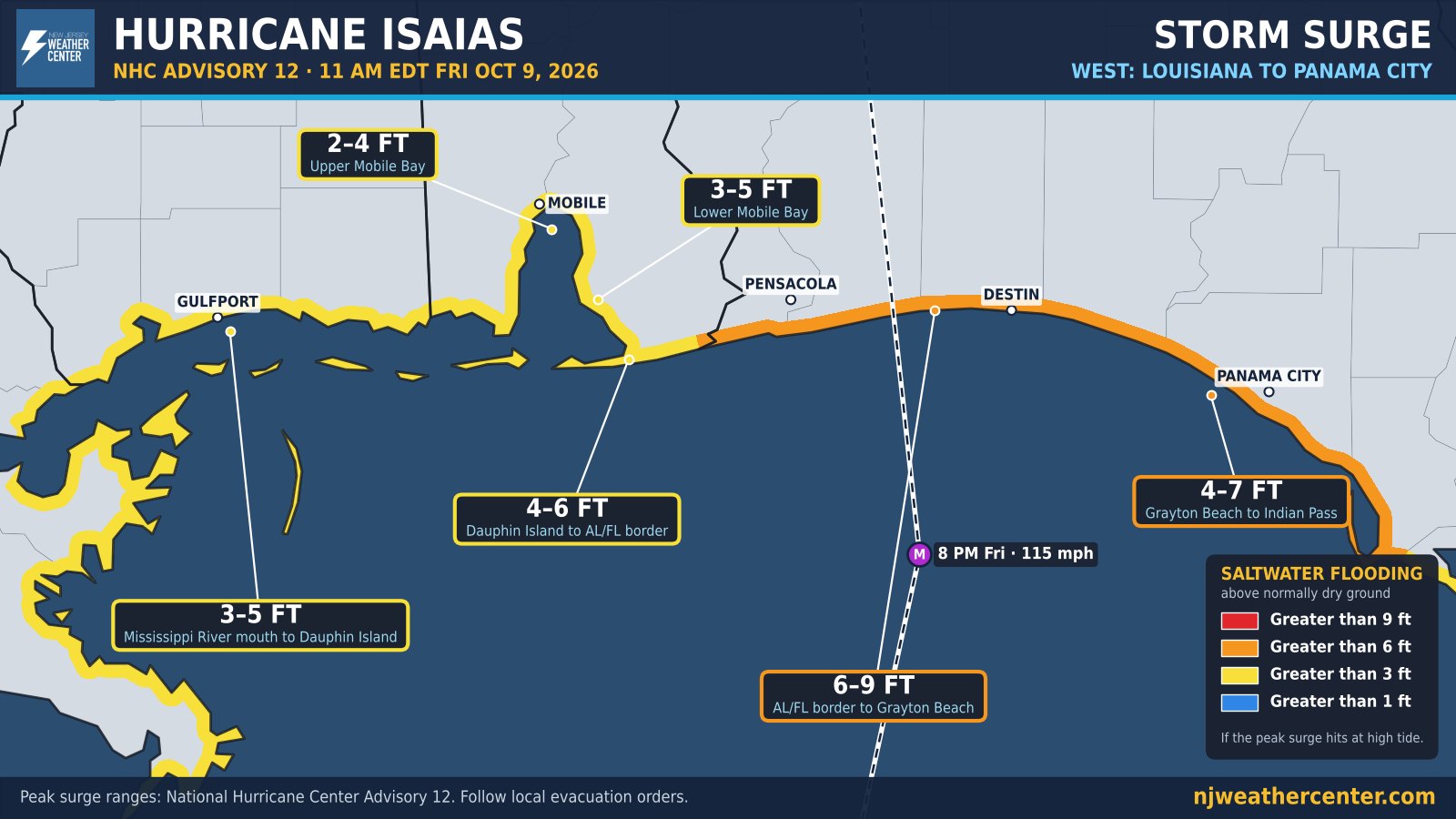
Storm surge map, west half: Louisiana to Panama City. NHC Advisory 12 peak surge above ground: Mississippi River mouth to Dauphin Island 3 to 5 feet, Lower Mobile Bay 3 to 5, Upper Mobile Bay 2 to 4, Dauphin Island to the Alabama/Florida border 4 to 6, Alabama/Florida border to Grayton Beach 6 to 9, Grayton Beach to Indian Pass 4 to 7.
Storm surge, Louisiana to Panama City. Ranges from NHC Advisory 12.
Storm surge map, east half: Panama City to Florida's Big Bend. NHC Advisory 12 peak surge above ground: Grayton Beach to Indian Pass 4 to 7 feet, Indian Pass to the Steinhatchee River 4 to 6, Steinhatchee to Suwannee River 3 to 5, Suwannee River to Yankeetown 2 to 4.
Storm surge, Panama City to the Big Bend. Ranges from NHC Advisory 12.

For us: no direct hit. Isaias weakens over Alabama Saturday and its leftovers head northeast, reaching us Sunday. The National Weather Service expects a soaking rain Sunday afternoon into Sunday night: about 1 inch in North Jersey and around NYC, 1.25 to 1.75 inches along the Shore and in South Jersey, with some spots over 2 inches. Gusts could reach 25 to 35 mph near the coast Sunday night. Flooding is mostly the street-and-poor-drainage kind, and minor tidal flooding is possible Sunday into Monday.

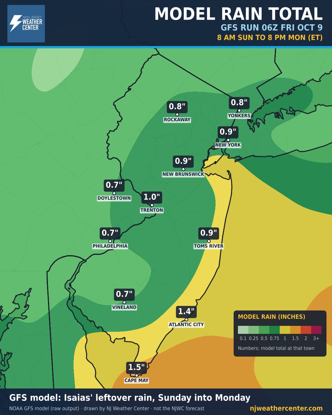
What the models show: this is our drawing of NOAA's GFS computer model for 8 PM Sunday, with steady rain over New Jersey. The GFS is on the drier side, about 0.7 to 1.5 inches through Monday evening. It's one model, not our forecast.
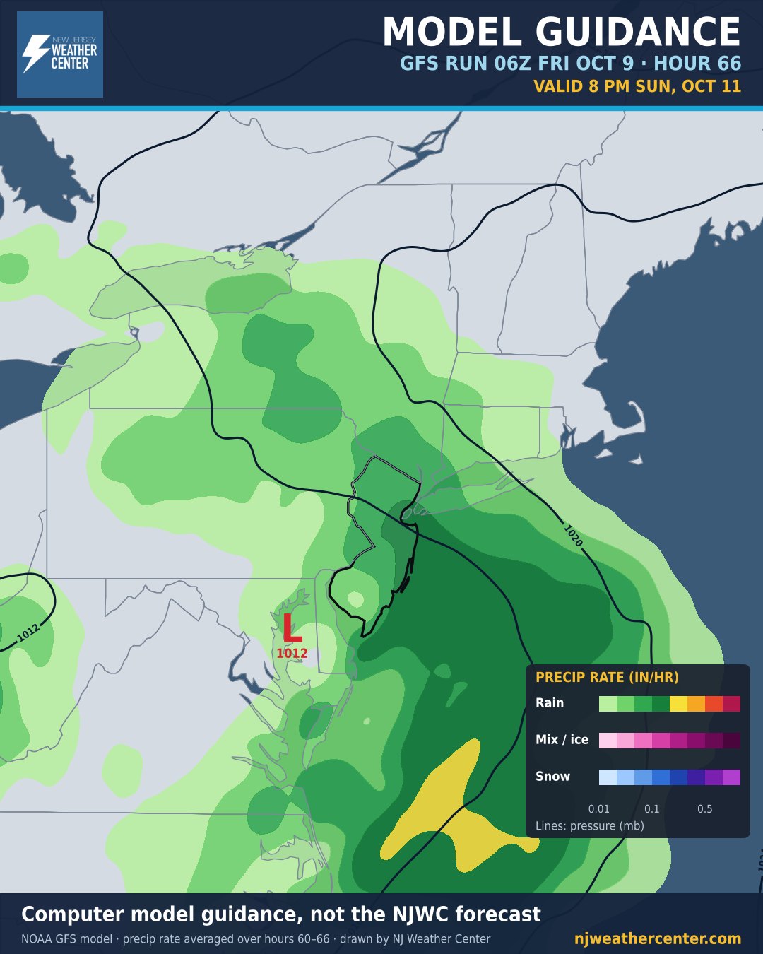
GFS computer model guidance, 06Z Friday run, valid 8 PM Sunday, October 11: steady rain over New Jersey and the ocean just to the east, heaviest offshore, with a weak low over the Delmarva. Computer model guidance, not the NJWC forecast.
GFS model, 8 PM Sunday. Computer model guidance, not the NJWC forecast.
GFS computer model rain total from 8 AM Sunday to 8 PM Monday: about 0.7 to 1 inch for most of New Jersey, Philadelphia and New York, 1.4 inches at Atlantic City and 1.5 inches at Cape May. Computer model guidance, not the NJWC forecast.
GFS model rain total, 8 AM Sunday to 8 PM Monday. Not the NJWC forecast.
Sources: National Hurricane Center (NOAA), Advisory 12, 11 AM EDT Fri, Oct 9 · NWS alerts (inland watches and warnings, pulled 12:04 PM EDT) · NWS Mount Holly and Upton forecasts and forecast discussions, Fri, Oct 9 · NOAA GFS model, 06Z Fri run. Always follow official NHC and NWS advisories.